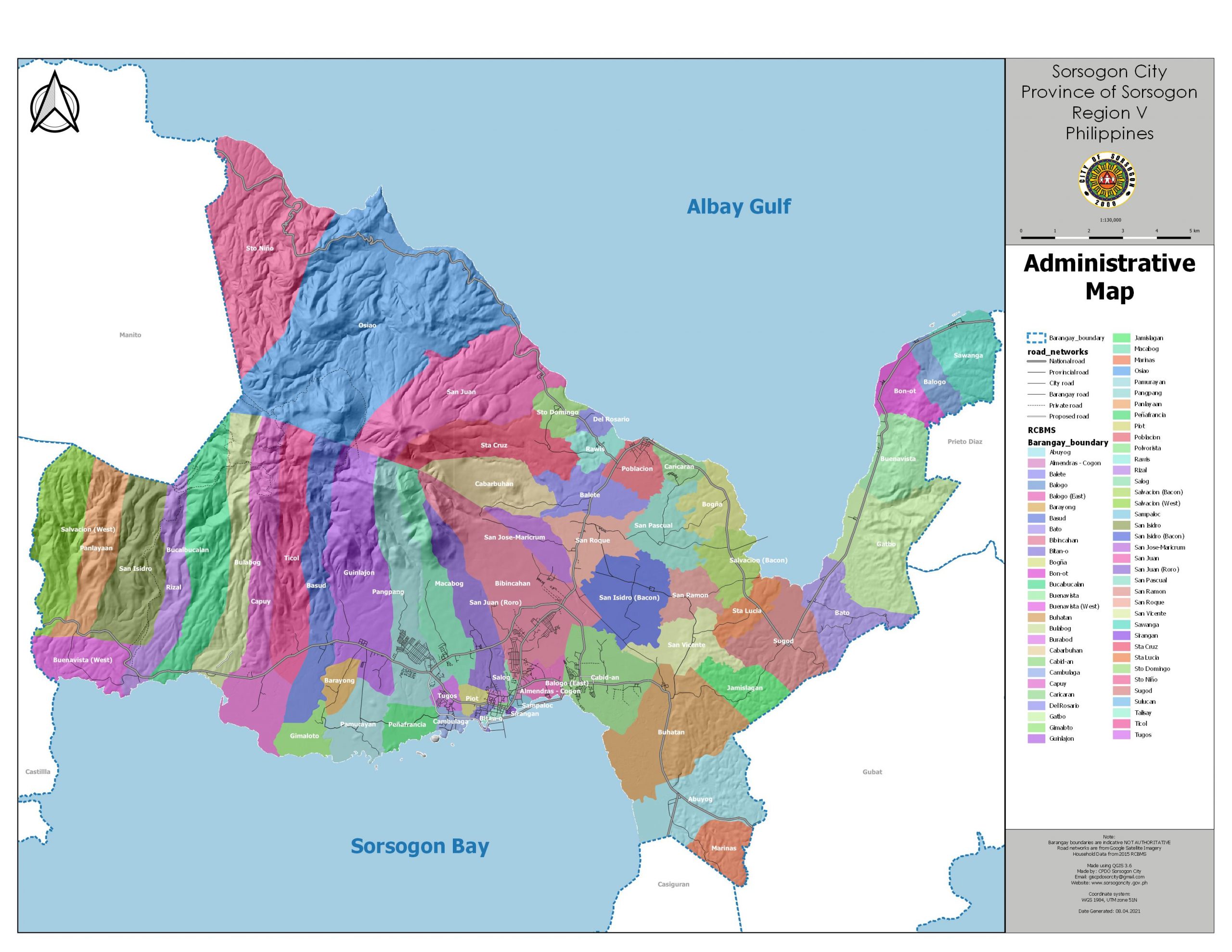
Location and administrative boundaries
The City of Sorsogon is located at the Province of Sorsogon, which forms part of the Bicol Region or the Region V. The Bicol region is composed of six (6) provinces, namely: 1) Albay, 2) Camarines Norte, 3) Camarines Sur, 4) Catanduanes, 5) Masbate and 6) Sorsogon. The Province of Sorsogon, lies at the southernmost tip of Luzon Island (Figure 2-1). It is surrounded by bay-like geological formations and several narrow tributaries or bodies of water.
Sorsogon City, which is the capital of Sorsogon province lies from 123° 53’ to 124° 09’ east longitude and from 12° 55’ to 13° 08’ north latitude. It is bounded on the east by the municipalities of Prieto Diaz and Gubat, on the west by the Municipality of Castilla, on the south by the Municipality of Casiguran and Sorsogon Bay, on the north by the Albay Gulf and on the northeast by the Municipality of Manito in Albay. The total land area covered by the City of Sorsogon is 27,528.6872 hectares or 275 sq. km. and is composed of sixty-four (64) barangays.

Land Area and Political Subdivision
There are three major areas withinSorsogon City, first is the Bacon district (black) having 28 barangays, second is Sorsogon West (blue) district having 22 barangays and third is Sorsogon East (yellow) district, which has 14 barangays.
Geologic Structure
The Geologic structure in the northeast of the city are made of limestones (Sorsogon Marl, Gatbo Limestone and formations), which is a good source of marble and are extracted through quarrying. The rest of the flatlands are recent alluvial deposits composed of sand, silt, clay, gravel, and corral. Figure 2-5 shows the Geologic Map of Sorsogon City. The northern part of Sorsogon City consists of volcanic rocks such as Volcanoclasts and Quaternary Volcanics. The said part is also consists of andesitic lava flows and typically contains between 52% to 63% silicon dioxide or silica. The border shared by the Municipality of Manito, Albay and the Municipality of Bacon, Sorsogon is home to the Bacon-Manito (Bacman) Geothermal field which is situated within the Pocdol volcanic range of which the active volcanoes of Mt. Mayon and Mt. Bulusan are also part of. These volcanoes are part of the Bicol Arc, of which according to the National Geothermal Association of the Philippines is a ―northwest-trending chain of Late tertiary-Quaternary eruptive centers associated with the subduction of the Philippine sea plate along the northern edge of the Philippine Trench.‖ This suggests that the Bicol region is host to active volcanic clusters that largely characterizes its geological formations.


Soil type
The Bacon district soil type is largely of the Annam clay loam or Clay Loam. The Sorsogon City proper, on the other hand, is mostly of the silt clay loam type, which is suitable to lowland rice, fiber crops such as abaca and corn. More than 50% of the land area is composed of the Annam clay loam and this soil type has a relief of slightly undulating, roughly rolling to undulating. It is also ―well drained to excessively-drained and fairly drained internally. It is prone to erosion and care should be given in not cultivating under a clean tilled cropping system. It is suited to lowland rice, root crops, vegetables, and permanent planting.
Rainfall
Generally, the climate of Sorsogon is under Type II of the Coronas classification system. Under Type II, there is no pronounced dry season but with a very pronounced maximum rain period from November to January. Sorsogon’s annual rainfall range from 2,800 mm to 3,500 mm. Rain is expected 200 days in a year and even in the driest months unexpected downpour occurs.
Atmospheric Temperature and Relative Humidity
Temperature in the Sorsogon City ranges from 21 0C to 32 0C. Relative humidity is 82%. Prevailing winds are the monsoons and Pacific Trade Winds. The Northeast Monsoon (Amihan) occurs from October to March while the Southwest Monsoon (Habagat) occurs from June to September. The Pacific Trade Winds (Gurang na Habagat) occurs during April and May.
